Written by Violeth Swai, Stephan Amm and Qaiser Hussain
The trail towards Aspevatnet and Blåvatnet starts at the parking lot. After a few hundred meters, the trail splits towards lakes Blåvatnet (4km) and Aspevatnet (700m). Further up the valley (approximately 400m) towards Blåvatnet, where you see elevated ridges in front of you with a ri
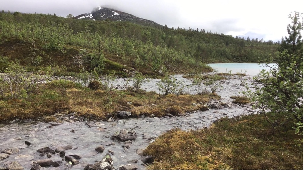
Figure 1: The shoreline in Aspevatnet Lake catchment, vegetated with a flat surface. Before the shoreline, only a small meltwater stream enters Aspevatnet after being branched from the main river. Photo: Violeth Swai
ver cutting through them, Strupskardet Valley is reached, which is the former base of the Lenangsbreen glacier.
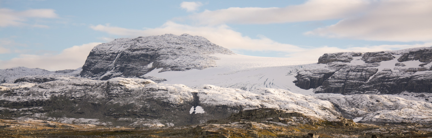
Around 20 000 years ago, during the peak of the Ice Age, Lenangsbreen Glacier covered the valley. During this time, the sea level around Strupskardet was higher (around 90m higher than today) due to isostatic depression—rising of sea level resulted from an increase of weight of the land after storing water in glaciers—between the land and the sea. When a glacier moves and erodes, it breaks the underlying and surrounding rocks into pieces in different sizes (unsorted debris). This glacialdebris is then pushed forward or laterally as the glacier grows/moves, then accumulate to form ridges known as moraines. The Lenangsbreen glacier started to retreat earlier than 11 700 years before present, at the start of the present interglacial (warm) period – the Holocene. As a result, various landforms that were created during glacial periods were exposed, including the U-shape of the valley, glacial sediment, glacial lakes, meltwater streams and moraines.
The moraines signify glacier advances or a steady state when a glacier positioned at the same spot for a long time. In the Strupskardet valley, the moraines are spectacular and provide snapshots of various stages of glaciers advance/halt through time. The oldest are close to the fjord and the youngest above the fan further up-valley from Blåvatnet.
Stop 1: Past shorelines
At an elevation of 60m above sea level you will find the remnants of the past shoreline that was formed between 12 800 and 11 700 years before present (the Younger Dryas period). Below this elevation, young shorelines exist, one of them (age around 10 400 years, 34m elevation) is found within Lake Aspevatnet catchment (Figure 1). The shorelines indicate how high or low the sea level was during a certain period, which is largely depending on whether isostatic rebound exceeds/subceeds eustatic sea level change. The rise of a land mass after removal of heavy weight of ice sheet/glacier, which had made a depression before is known as the isostatic rebound while a decrease (increase) of the local sea level after an uplift (depression) of the land mass is the isostatic sea level. Even though they are formed by different processes, ridges of moraines and past shorelines may look similar, especially if they are densely vegetated. A quick identification of the shoreline is by looking at its flat hill-shape and well sorted (similar range of grain size) rounded beach gravelsIn contrast, ridges of moraines are less flat and composed of unsorted and angular sediments including large boulders.
Stop 2: The meltwater river streams
As you go further north, the gravels and boulders you step on were deposited when the glacier was melting. Glaciers retreat due to higher temperatures and/or less snowfall. As a result, meltwater streams were formed that have been washing away and transport fine glacial sediments downstream. There, the main stream divided into two branches, carrying the sediment to Aspevatnet Lake and to the fjord.
Stop 3: The “Younger Dryas” moraine
Further north into the valley, as you approach the head of the valley, in front of you there are huge boulders formed in a semi-circular shape: this is moraine complex formed during the Younger Dryas period (around 12 800 years before present). The period occurred at the end of last glaciation when patterns of oceanic and atmospheric circulation in the northern Atlantic altered, likely in response to freshwater forcing from melting ice sheets. . Before this disruption, the region was emerging from the Last Glacial and experienced warmer conditions. Input of freshwater triggered the formation of extensive sea ice, which changed the direction of westerlies from north to south. This cooled northern Europe and triggered glacier advances. The period was named after the white dryas flower (Dryas octopetala), that grows in cold conditions and was very common in Europe during this period.
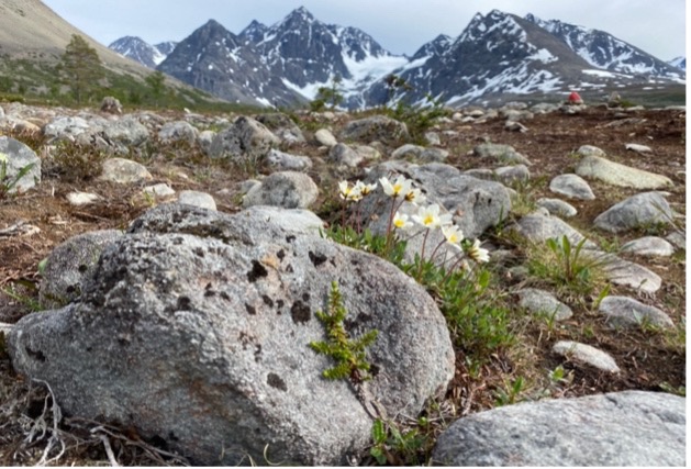
Figure 2a: The white dryas flowers behind a boulder, a perfect combination of beauty and climate history. Photo: Stephan Amm
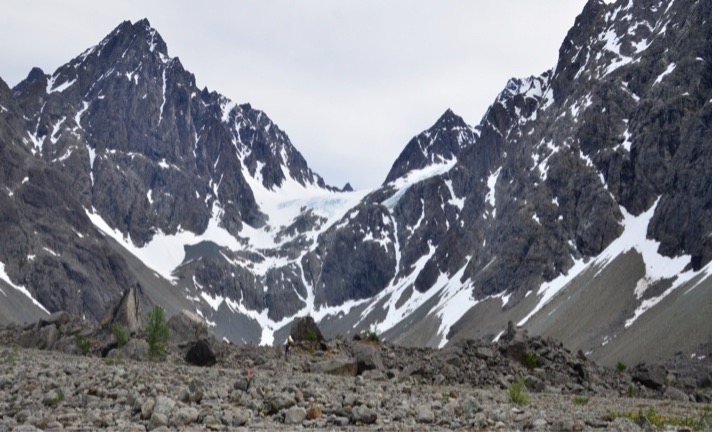
Figure 2b: The Younger Dryas moraine covered with huge boulders; the moraine system is slightly sealing Lake Blåvatnet. Photo: Stephan Amm
Stop 4: Lake Blåvatnet
Blåvatnet is one of the glacial lakes found in the Strupskartet valley. It was formed when a depression left behind by a retreating glacier, partly dammed by the terminal moraine, was filled with glacial meltwater and sediment. The lake obtains its beautiful blue colour from suspended silt/clay particles (glacial flour) from rocks grounded by a moving glacier. Meltwater streams from Lenangsbreen transport sediments into Blåvatnet, where they accumulate through time to form a continuous record of glacier activity. In Blåvatnet, sediments are trapped before the finer fraction is transported further downstream into Aspevatnet Lake and the fjord.

Figure 3: Stunning Lake Blåvatnet sealed by slopes of the Lenangsbreen and Younger Dryas moraines. Photo: Stephan Amm
Stop 5: Lake Aspevatnet
While following the trail to Aspevatnet Lake, the river on your left side drains water from the valley and the lake which will end up into the fjord. At the lake, the eye-catching blue colour of water signifies how much sediment is going into the lake through time. Most of glacial sediments are already filtered in up-stream Blåvatnet, making Aspevatnet Lake well suitable for obtaining a long and continuous record of glacier and catchment history within a few meters of sediments (due to low sedimentation rates). Initial results from a sediment core drilled on June 22nd, 2021, in Aspevatnet reveal changing in deposition from glacier (G), lake productivity (O) and flood (F) input (Figure 4). Glacial input dominates the upper section (young) from 0-53cm depth which composed of greyish/yellowish grey minerogenic sediment. Below, at depth 53-57cm (old) layers of organic sediments with brown colour and various thickness exist. These represent a period when lake deposition dominates, probably due to weak/no input from the glacier after a complete snowmelt. The organic layers can be from primary productivity of plant(like) organisms (including microalgae) living in the lake. The alternating greyish and brownish layers indicate a shift in deposition between glacial and non-glacial (organic) environment. Furthermore, a thick dark-brown layer probably deposited by a flood event is found at the lower section (older) from depth 64-68.5cm. Indeed, further investigation of sediment is needed to determine their precise origin and nature of their deposition. This includes analysis of their grain size, chemical elements and organic composition in relation to age of the sediment.
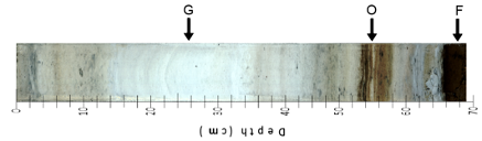
Figure 4: Sediment from Lake Aspevatnet showing a transition from nonglacial to glacial environments. Photo: Violeth Swai
More information about the science behind the valley and its glacial lakes can be found here, https://www.researchgate.net/publication/240738301_Glacier_fluctuations_equilibrium-line_altitudes_and_palaeoclimate_in_Lyngen_northern_Norway_during_the_Lateglacial_and_Holocene